Floodplain Management
How to Determine if your Property is in a Floodplain:
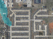
Use the online map created by the Oklahoma Water Resources Board, or
Use the Mustang GIS map (the username and password is mustang) or
Use the FEMA map and enter your address in the search box or
Come in person to 1501 N. Mustang Road
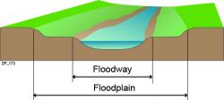
In addition to obtaining a building permit, anyone who desires to construct improvements or to excavate in or around the 100-Year (1% Chance) Floodplain could also be required to file for a Floodplain Development Permit . These permits are not easily obtained and often require the owner to utilize the professional services of an engineer, surveyor or architect as mandated by the Oklahoma Water Resources Board and the Code of Ordinances of the City of Mustang (Chapter 50, Article II).
Individuals aggrieved by the administration of our floodplain regulations may file an application for a variance with the board of adjustment. These type of variances are extremely rare and must be filed on record with the Oklahoma Water Resources Board. They are also subject to review by the Federal Emergency Management Agency.
Supporting Documents
Flood Plain Development Permit (28 KB)
Web Links


